")
")
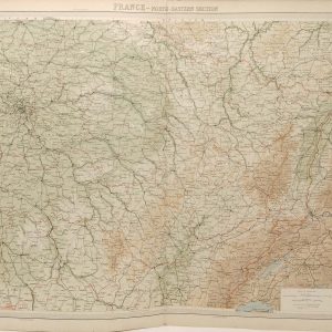
France South Eastern Section Antique Map 1922
€29.95
Large antique map from 1922 of France South Eastern section, smaller maps of Corsica and Marseille on bottom right.
1 in stock
Large antique map from 1922 of France South Eastern section, smaller maps of Corsica and Marseille on bottom right.
The maps cartographer was J. G. Bartholomew and was originally published as part the survey atlas done by the Times in 1922.
The map is large 58 cm’s by 45 cm’s and is suitable for framing. Condition wise, map is in very good condition for age and intact, paper will show signs of ageing, map was released as a fold out map , so fold line present, map is clean for age, please see pictures.
Additional information
| Weight | 0.2 kg |
|---|
You Might Also Like
-

Brittany Spaniel 1938 Vintage Print
€34.95 Add to cart -
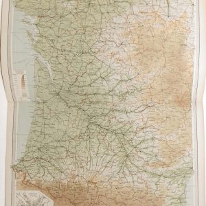
France South Western Antique Map 1922
€29.95 Add to cart -
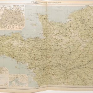
France North Western Section Antique Map 1922
€29.95 Add to cart -

Pont-Audemer Spaniel 1938 Vintage Print
€34.95 Add to cart -

Barbet 1938 Vintage Print
€34.95 Add to cart -

Gordon Setter 1938 Vintage Print
€34.95 Add to cart -

German Pointer 1938 Vintage Print
€34.95 Add to cart -

French Spaniel 1938 Vintage Print
€34.95 Add to cart -

Picardy Spaniel 1938 Vintage Print
€34.95 Add to cart -
France North Eastern Section Antique Map 1922
€29.95 Add to cart